Notice: On Tuesday, February 19, 2019 the County Board voted to phase out the website sheridancountyne.com in favor of a new website at sheridancounty.ne.gov. Retired Commissioner Andersen, having developed - maintained and backed up the original site, moved the information to this site for public use. For official information be sure you are on sheridancounty.ne.gov. We invite you to browse our web site to learn about our various County offices and the services Sheridan County, Nebraska offers its citizens. This web site contains information about County departments and offices, as well as helpful information on commonly asked questions. Please contact Jack Andersen if you have any questions, comments or suggestions on how we can improve this web site.
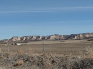
 Located North of Hay Springs the Beaver Wall is a sharp contrast to the rolling sand hills located in southern Sheridan County.
(Photo courtesy of Bill Van Kerrebrook) By land area, Sheridan County is the fourth largest county in the State. It is 36 miles wide by 69 miles long. According to the U.S. Census Bureau, the county has a total area of 2,470 square miles. The population of Sheridan County in 2010 was 5,469. The economy is based mainly on Agriculture. The southern portion is sandhill range land while the north contains pine covered hills. Depending upon water from the Box Butte Reservoir, Mirage Flats Irrigation District is located south of Hay Springs. There is considerable farming, both dry land and pump irrigated, either side of US Highway 20. There are four incorporated towns within the County of Sheridan. They include the County Seat of Rushville (population 850), Gordon (population 1612), Hay Springs (population 570), and Clinton (population 41). There are also five unincorporated villages within the county's boundaries. They are Antioch, Bingham, Ellsworth, Lakeside, and Whiteclay. Related Links Counties Bordering Sheridan County |